Hydrogeology
What is the Hydrologic Cycle
There is a finite supply of water on the Earth, but it is continually recycled naturally. Water may occur as a solid, liquid, or gas, and can be found in a wide variety of locations. This circulation that purifies and redistributes water is called the hydrologic cycle.
Water can enter the atmosphere by evaporation, transpiration, or sublimation. Evaporation occurs as liquid water becomes a gas; the water can come from anything on the surface, such as plants, soil, rivers, lakes, and oceans. Transpiration is the process by which water is released from green plants into the atmosphere. In many cases it is very difficult to distinguish evaporation from transpiration; evapotranspiration refers to the combination of the two. Sublimation is the process of a solid turning directly into a gas; snow and ice changing into vapor is only a minor part of water entering the atmosphere.
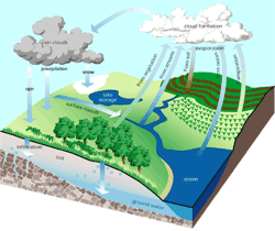
Water changes from a gas into a liquid by condensation and returns to the Earth primarily in the form of precipitation (snow and rain). Many different things can happen to precipitation in some cases it does not even reach the ground. It can evaporate before hitting anything, or can be intercepted by vegetation. When water reaches the ground, it can infiltrate into the ground, be stored on the surface, or travel on the surface until it can infiltrate or be stored.
Groundwater travels through rock and sediment by percolation. It moves by gravity and pressure until the water table intersects the ground surface. Water can then be discharged at springs or any other body of surface water. Once returned to the surface, this water can be used by plants, stored on the surface, or evaporated.
Importance of the Hydrologic Cycle for Groundwater
Infiltration supplies aquifers with a continual source of water to replace that pumped from wells and discharged naturally (such as at springs). During infiltration water can pick up acids in the soil that can subsequently expand the pore space in aquifers, sometimes creating caves. Large areas of impervious cover, such as parking lots, do not allow infiltration. High volumes of rain over a short period of time also reduce the amount of water infiltrating; slow rainfall best recharges groundwater.
Infiltration and percolation are usually slow processes requiring water to move through a tight maze of sediment which acts as a filter. Together with biological activity, water is cleaned as it moves through the ground. This natural scrubbing is one of the reasons groundwater is so commonly used for drinking.
Definition of an Aquifer
These characteristics vary according to porosity and permeability. Porosity is the percentage of open space in a rock. Permeability is the degree to which a rock allows the transmission of fluids through these pore spaces. Even if a rock has high porosity and contains water, it is not considered an aquifer unless it has high enough permeability to get the water out.
Parts of an Aquifer
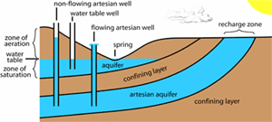
Less permeable rock below an aquifer that keeps groundwater from draining away is called a confining bed (also known as aquitard or aquiclude). The water table in an aquifer is at the very top of the zone of saturation (the zone where water completely fills all the interconnected pore spaces). Water in this zone is called phreatic water. Between the water table and the land surface is the zone of aeration, which can also contain some water (known as vadose water). At the bottom of the zone of aeration, water usually occurs a few centimeters above the water table due to capillary action. At the top of the zone of aeration, water may be held in the soil. Water in the intermediate area of the zone of aeration is usually moving down toward the zone of saturation.
When an aquifer is bounded on top and bottom by confining beds, it is called an artesian aquifer. Water enters an artesian aquifer where the confining layer is absent from the recharge zone. Water in an artesian aquifer is under pressure from the weight of the water at higher elevations. Because of this pressure, wells drilled into an artesian aquifer will have water forced up. If the water level is higher than the elevation of the land in the area, it is a flowing artesian well.
Types of Aquifers
By use: A primary aquifer is the single most important economic source of groundwater in an area. Aquifers supplying minor amounts are secondary aquifers. A sole source aquifer provides all of the drinking water to an area.
By location: Bedrock aquifers occur in consolidated rock. Surficial (or water table) aquifers occur in unconsolidated sediment between the soil and bedrock. Perched aquifers are small and separated from a main aquifer below it by a confining layer and a zone of aeration. Artesian aquifers are bounded above and below by confining beds.
By host rock: Most aquifers occur in carbonate, clastic, or volcanic rocks. Aquifers in carbonate rocks (also called karst aquifers) transmit water through fractures or dissolved passages. Clastic aquifers may be consolidated or unconsolidated and transmits water slowly through the spaces between sediments. Volcanic rocks, when fractured, can have very high permeability, but this type of aquifer is rare in Texas. Other rock types, such as granite in the Llano region of Texas, can also act as a local aquifer when fractured.
References
Gunn, J. 2004. Encyclopedia of Caves and Karst Science. Fitzroy Dearborn, New York, 902 pp.
Groundwater Flow Paths
Groundwater only moves if there is sufficient pressure to force it through pore spaces. Three forces act on groundwater: gravity, external pressure (from the atmosphere and overlying water), and molecular attraction. Groundwater will move from an area of high pressure to an area of less pressure if the permeability of the surrounding material permits (Fetter, 1994).
In clastic aquifers, water flows around individual grains in a windy path. The packing, sorting, and shape of the grains determine the flow in these aquifers. If sediments are solid spheres of equal diameter, cubic packing (each sphere sits directly on the crest of the underlying sphere) produces almost twice the porosity of rhombohedral packing where spheres lie in the hollow formed by four adjacent spheres (Meinzer, 1923). Poorly sorted sediments contain multiple grain sizes with smaller particles filling void spaces between the larger ones, thereby reducing porosity. Spherical (or equidimensional grains will pack more tightly than other shapes. Additionally, if the sediments in a clastic aquifer are compacted or cemented, porosity will be reduced.
Whereas porosity in clastic rocks is mainly in the spaces between the grains (primarily porosity), carbonate and igneous rocks transmit water mainly via secondary porosity (fractures and dissolved openings).
Directions of Flow

Although the dominant pressure acting on groundwater is gravity, this does not mean that water will always flow down. Artesian aquifers force water to flow up a well because all the groundwater is susceptible to gravity and it is trying to reach the overall lowest level of pressure. If an artesian aquifer is not recharged, it will eventually stop flowing. In all cases, water that is moving up, rather than down, is doing so because of pressure; in most cases, this pressure is exerted by gravity on water elsewhere in the aquifer. Water usually has multiple possible flow paths, with the quickest being most commonly taken.
Rates of Flow
Rates of groundwater flow vary greatly according to the permeability and porosity even when the pressure exerted is constant. Flow through sandstone can be only cm per day; well-sorted gravel may allow rates of 100 meters or more a day. Karst aquifers with exceptionally large conduits can exhibit flow rates of several kilometers per day.
References
Fetter, C. W. 1994. Applied Hydrogeology. Macmillan, New York, 691 pp.
Meinzer, O. E. 1923. The occurrence of groundwater in the United States, with a discussion of principles. U.S. Geological Survey Water Supply Paper 489.
Types of Interactions
Groundwater affects a wide range of geologic processes, such as ore deposition, petroleum migration, heat transfer, earthquakes, diagenesis, volcanism, and metamorphism (Ingebritsen and Sanford, 1998). This section focuses only on select aspects of interaction between groundwater and rock near the surface.
Solute Transport
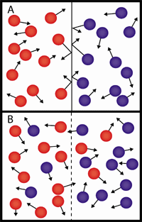
B – Same waters with boundary removed. Mixing occurs by molecular diffusion.
The transport of dissolved chemical constituents, solutes, in groundwater is a significant component of many geologic processes. Transportation of solutes occurs primarily through three methods:
- Molecular diffusion is the diffusive flux of solutes along a concentration gradient. This process is driven by the random motion of ions in solution. Ions in a region of higher concentration will eventually mix with ions in a region of lower concentration to create an equal distribution in space.
- Advection is the movement of solutes with flowing groundwater where the solutes move at the same rate as the groundwater. Most economically-significant ore deposits exist because of advective transport of solutes and heat. These deposits are produced when groundwater circulates to depth, heats up, and dissolves a solute from throughout a large volume of rock. As the hot water moves into cooler areas of the crust, the dissolved substances are precipitated. If cooling occurs very quickly minerals will be precipitated in a very limited space (Skinner, 1979).
- Mechanical dispersion depends on a difference in solute concentration, as in molecular diffusion, but the mixing occurs as a result of the physical movement of water. Therefore, where concentrations differ, solutes are transported via molecular diffusion when flow velocities are low, and by mechanical dispersal when flow velocities are high. Because mechanical dispersal is velocity dependent, it is controlled by the characters of the rock layer. Faster movement occurs in areas with larger pore spaces, shorter flow paths, and lower friction.
Solute Transport in Texas
The most obvious effects of solute transport by groundwater in central Texas are caves. As slightly acidic water passes through limestone, it dissolves away calcite and carries it in solution. Openings develop in the rock, ranging in size from microscopic fissures to massive caverns. Water can become supersaturated as it evaporates, and re-deposit calcite (Gunn, 2002).
Heat Transport
Hydrothermal circulation partially explains the non-uniform distribution of heat through the Earth’s crust. Heat can be advected by moving water or conducted through the rock-water medium. This is dynamically displayed at geysers such as those at Yellowstone National Park. Boiling water suddenly discharges through a tight opening. Once the pressure is released by the discharge, the groundwater temperature falls back below boiling (Bryan, 1999).
References
Bryan, T. S. 1999. The Geysers of Yellowstone. Third Edition. University of Colorado Press, Niwot, Colorado, 463 pp.
Gunn, J. 2004. Encyclopeadia of Caves and Karst Science. Fitzroy Dearborn, New York, 902 pp.
Ingebritssen, S. E., and W. E. Sanford. 1998. Groundwater in Geologic Processes. Cambridge University Press, Cambridge, 341 pp.
Skinner, B. J. 1979. The many origins of hydrothermal ore deposits; pp. 1-21 in H. L. Barnes (ed.), Geochemistry of Hydrothermal Ore Deposits. John Wiley, New York.
Types of Wells
In many areas, wells are the only way to access groundwater. There are three most common wells based on how they are made: dug wells, driven wells, and drilled wells (Waller, 1999).
The most primitive way to make a well is to dig it with a pick and shovel. This method only works well when the ground is relatively soft and the water table is shallow. Dug wells are often lined with stones to prevent them from collapsing.
Driven wells are built by driving a small diameter pipe into soft ground, like driving a nail into wood. Driven wells are only efficient at reaching shallow water.
Drilling is the most common way to create a well today. Shallow wells can be drilled with a hand auger, but most wells are drilled with a drill rig mounted on a truck. Drilled wells can reach more than 1,000 feet.
Water Levels in Wells
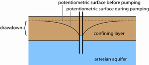
Water levels in wells vary according to seasonal variations in rainfall, recharge rate, and pumpage. The surface that represents the level to which water will rise in a tightly cased (sealed) well is the potentiometric surface. This surface is the result of all the pressures on groundwater. The water table is a particular potentiometric surface for unconfined aquifers. The water surface in a well into an artesian aquifer rises above the level of the aquifer because the water is being pushed toward the potentiometric surface (Fetter, 1994).
When water is pumped from a well faster than water can refill the pore spaces around the well, the potentiometric surface is lowered in the area of the well. The vertical change in the level of the potentiometric surface at the well is called the drawdown. Drawdown is most dependent on the rate of pumping. The three-dimensional deflection of the potentiometric surface around the well is the cone of depression, and is controlled by the speed of recharge to the pore spaces near the well.
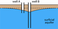
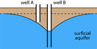
A cone of depression in one well can impact the water level in a nearby well. Above, well B is pumping out groundwater, thereby lowering the water level in well A, which is not pumping. If pumping at well B increases, the cone of depression can lower the water level sufficiently to leave well A dry (below).
References
Fetter, C. W. 1994. Applied Hydrogeology. Macmillan, New York, 691 pp.
Waller, R. M. 1999. Ground water and the rural homeowner. United States Geological Survey, Denver, 38 pp.